TNow Request a demoDemo

Know what a plot allows before you commit.

TNow pre-assesses land in mainland Portugal in minutes. It reads the municipal plan (PDM) category and cites the regulation by article in 278 municipalities, checks agricultural and ecological reserves, the coast, floods, wildfire, cadastre, surroundings and grid, and hands you a report so you reach the council with the right questions.

For companies and technical teams. Pricing on request.
Drawing of test plot T001 in Paramos, Espinho, with the layers TNow reads 4 076 m N
T001, Paramos, Espinhotest plot
  • PDM: rural land, facilities area
    PDM Regulation, art. 41 and 42
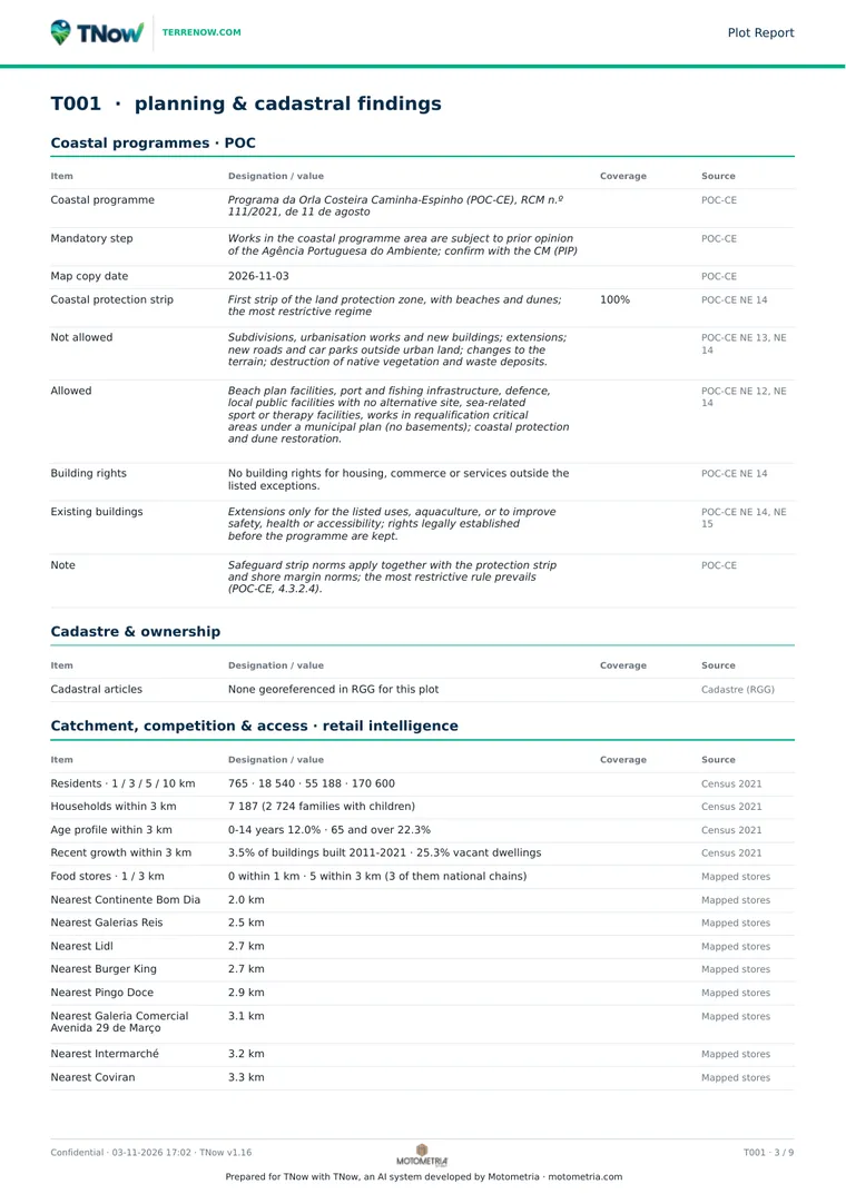
  • Coast: coastal protection strip on 100% of the plot
    Norms NE 12, NE 13 and NE 14
  • REN ecological reserve: overlaps the plot
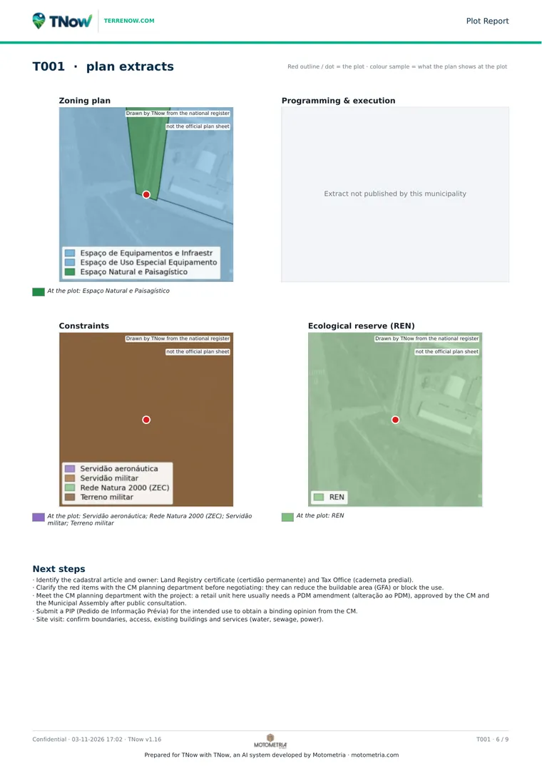
    Municipal REN boundary
  • Natura 2000: 100% of the plot
    Special area of conservation
  • Grid: 60 kV substation at 4,076 m
    24 MVA published hosting capacity
Report assessment: major constraints
app.terrenow.com
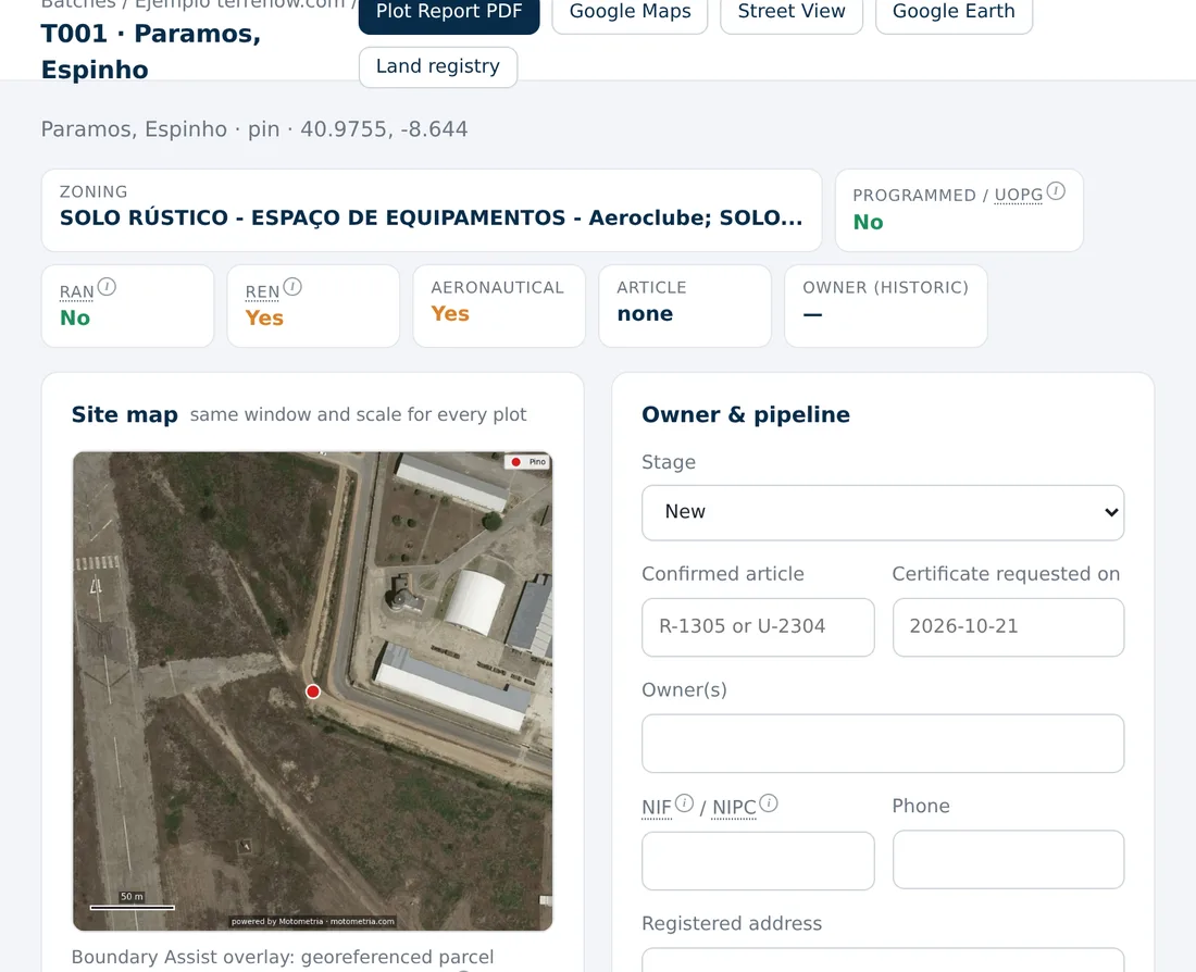
Plot page in the TNow app, with land class, RAN, REN, aeronautical easement and site map
Test plot T001 in the app.

Every plot read layer by layer, with the rule that applies.

In goes a Maps link, coordinates or a file. Out comes the share of the plot in each layer, the rule that applies and the article it comes from.

Zoning
PDM land class and category, with permitted uses, heights and indices cited by article of the regulation in 278 municipalities. A verdict for housing, industry, retail and services, with estimated buildable m².
Reserves and easements
Agricultural (RAN) and ecological (REN) reserves as a share of the plot, aeronautical and military easements, public water domain, power lines and roads.
Coast
The 4 coastal programmes in force on the mainland: protection strips, shoreline and erosion and overtopping safeguard strips as a % of the plot, with the numbered norms on what is banned and what is allowed.
Flood zones
Flood hazard class from very high to low, along rivers and on the coast, how much of the plot it covers and the rule that applies.
Wildfire
High or very high rural fire hazard and the share of the plot affected. From 25% it counts as a major constraint.
Planned retreat
Areas where the plan provides for removing the housing use, such as the Praia de Paramos settlement in Espinho.
Cadastre and land registry
Parcel, area, the tax article covering most of the plot and its neighbours. The land registry request comes ready per registry office, with article, parish, area and coordinates.
Surroundings
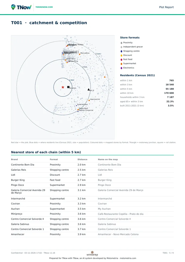
Residents within 1, 3, 5 and 10 km, households and age profile, and the nearest store of each retail brand, by format.

Dominant: installed collective facility (aerodrome, sports fields/urban park, fishing gear). Complementary: only uses directly related to or complementary to the installed activity.

Permitted uses on the test plot, cited from the Espinho PDM Regulation, art. 41 and 42

Find land across the whole country from your client’s brief.

Paste the brief as you received it, in Portuguese, English or Spanish. TNow fills in the criteria, searches municipality by municipality and returns plots ranked by a 0 to 100 score, with the reason for each criterion. Nothing runs until you confirm.

Example of a free-text brief

Looking for 2 to 5 hectares for a warehouse in the Aveiro district, on business-use land, within 5 km of a motorway junction and outside RAN and REN.

A real test in the Aveiro district

19municipalities searched
3,943parcels read
466plots that match

Criteria you can combine

  • Plot area and land class
  • Distance to motorway junctions and main roads
  • Railway stations, hospitals and schools
  • Town centres and industrial zones
  • Near or far from an address or a brand
  • Maximum slope and road frontage
  • Outside RAN, REN or Natura 2000
  • Residents within a radius

One municipality, several, a district, a NUTS region or the whole mainland. Results come as a map, KMZ and Excel, and become a batch in one click.
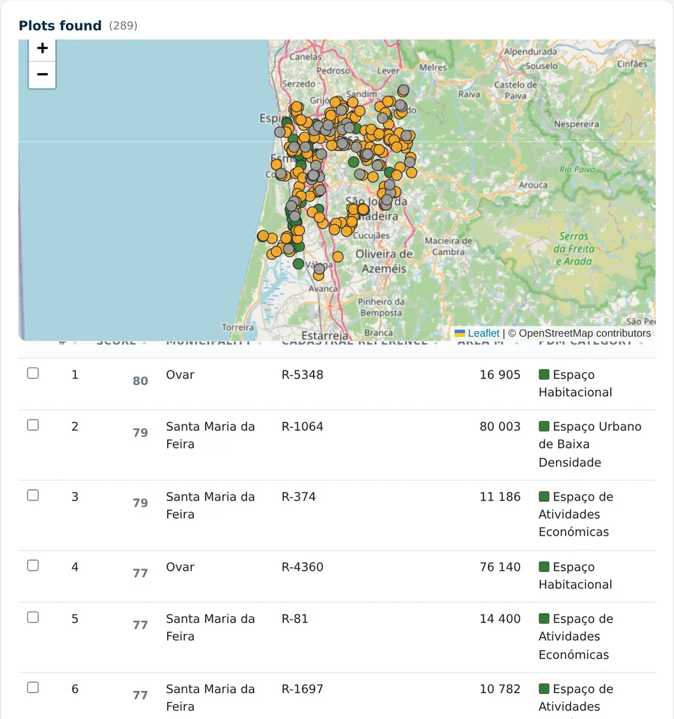
Land search results in the TNow app: map with the parcels found and a table ranked by score
Results of a test search: 289 parcels, the first with a score of 80.

Solar, wind and batteries: the grid next to the plot.

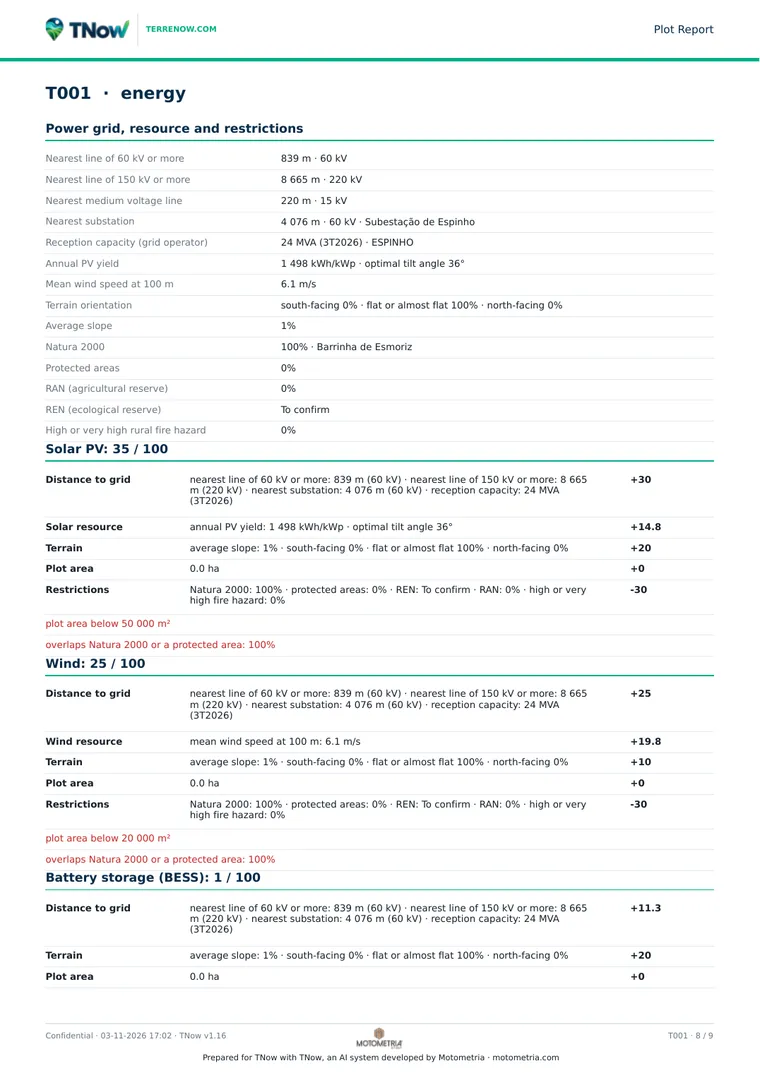
For each plot, the distance to 60 kV and 150 kV lines, the nearest substation and the hosting capacity published for that area. Add solar and wind resource, aspect and slope, Natura 2000 and protected areas.

4,076 mto the 60 kV substation
24 MVApublished hosting capacity
1,498 kWh/kWpannual PV yield
6.1 m/smean wind at 100 m

Values for the test plot in Paramos, Espinho.

Three base profiles, solar PV, wind and battery storage, give each plot a 0 to 100 score that opens to show each part: grid, resource, terrain, area and restrictions. When searching rural land, an energy profile applies a minimum area, 5 ha for solar, and a maximum distance to the grid.

The connection point and hosting capacity are then confirmed with the grid operator.
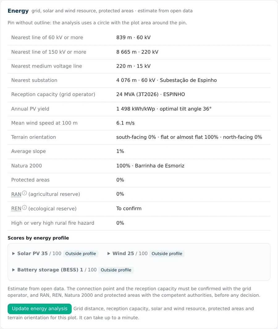
Energy section of a plot in the TNow app, with grid distances, hosting capacity, solar and wind resource
Energy section of the test plot.

In the way the plot reached you. Out ready to send.

Input

  • Google Maps link, coordinates or address
  • Tax article or property record
  • Photo with GPS location
  • Excel or CSV with a list of plots
  • KML, KMZ, shapefile or DXFwith the outline drawn

On the map

  • Edit the outlineredraw, move corners or pick cadastral parcels
  • Merge parcelstwo plots become one outline
  • Run againjust that plot, with its current outline
  • Compare2 to 3 plots side by side, or 1 plot for 2 to 3 uses

Output

  • PDF report per plotassessment, cited rules, plan extracts and next steps
  • Comparison PDFwith the same structure as the report
  • Excel dossier for the batchevery plot on one sheet, ready to filter
  • KMZ for Google Earthoutlines and neighbours
  • In Portuguese, English and Spanishthe same report for your team, your client and the investor

The official data stays on our side.

We keep copies of official public sources on our own servers, versioned and checked for changes. The analysis runs on our system instead of waiting for a public portal that is slow or down, and every report states when the documents were read.

This model already covers the main layers and is being extended to every source. When a layer cannot be read, the plot shows To confirm, never No.

From pre-assessment to the council

  1. Send the plotA link, a file with a list of plots or a point on the map.
  2. Read the reportAssessment at the top, then each layer with the share of the plot and the applicable article.
  3. Filter and compareDrop what has major constraints and compare what remains.
  4. Bring the right questionsA prior information request to the council, the land registry certificate and the grid operator, only for plots that pass the filter.

For people who decide on land.

Seven sectors use TNow in different ways. In the demo we show the workflow for yours.

Property developers

Screen dozens of plots a week and know, before paying for studies, which uses and indices the regulation allows. The verdict per use gives estimated buildable m² for housing, retail and services.

Retail and store expansion

Residents within 1, 3, 5 and 10 km, the nearest store of each brand and whether retail is allowed in the PDM category. The nationwide search finds plots near a motorway junction or away from a competing brand.

Logistics and industry

Business-use land of several hectares, road frontage, maximum slope and distance to motorway junctions and railway stations, in one municipality or a whole district.

Renewables and batteries

Distance to 60 and 150 kV lines, nearest substation and hosting capacity, solar and wind resource, and a 0 to 100 score for solar, wind and storage.

Funds and investors

A whole portfolio in one Excel dossier, with flood zones, coastal strips, planned retreat and wildfire as a share of each plot, before due diligence.

Consultancies and brokers

Answer clients with a report in Portuguese, English or Spanish and prepare land registry requests grouped by registry office.

Architecture and engineering

Start the feasibility study with the PDM category, the regulation articles, easements and plan extracts, and prepare the prior information request with the council.

See a real report.

Report generated by TNow on 3 November 2026 for test plot T001 in Paramos, Espinho. 10 pages: assessment, PDM and regulation, easements, coast with the norms, surroundings, plan extracts and energy. It holds no client data.
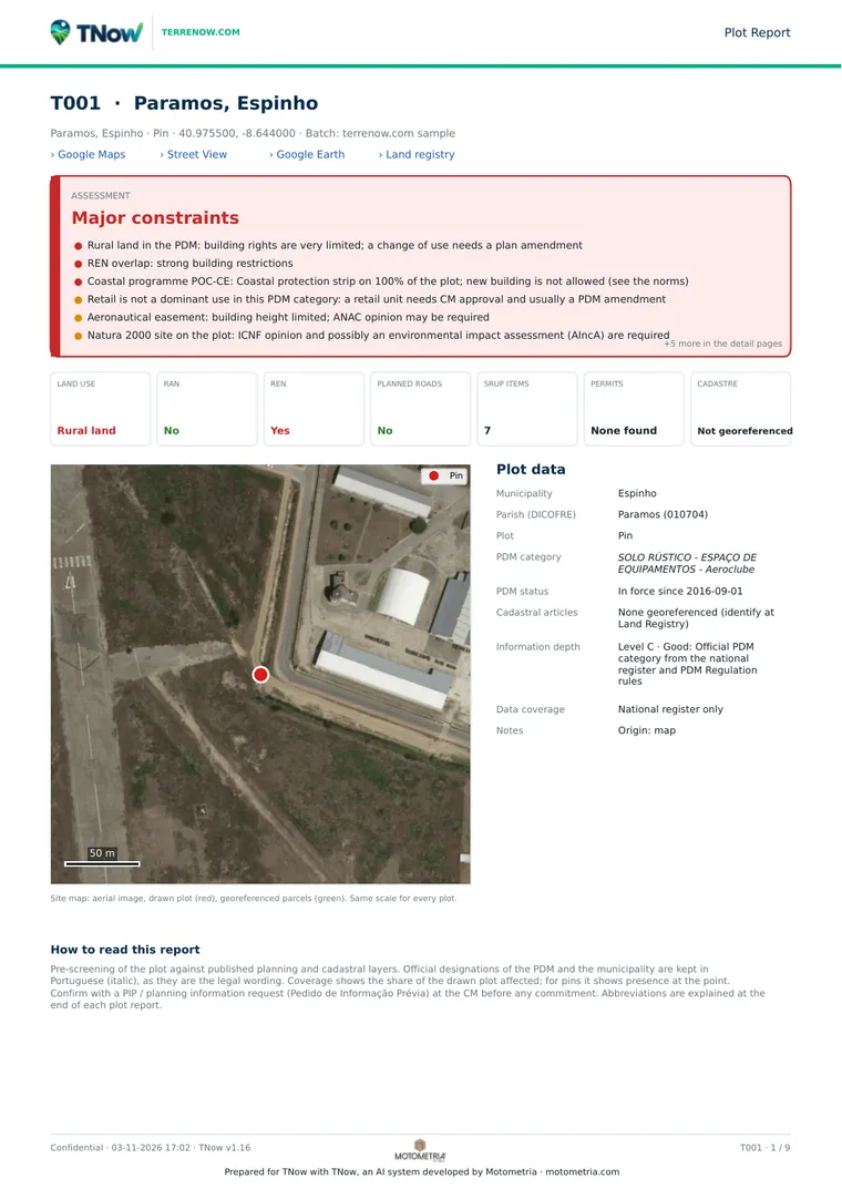
  • Page 1 of the sample report: Assessment and plot dataAssessment and plot data
  • Page 3 of the sample report: Coast with the numbered normsCoast with the numbered norms
  • Page 5 of the sample report: Surroundings and competitionSurroundings and competition
  • Page 6 of the sample report: Plan extracts and next stepsPlan extracts and next steps
  • Page 8 of the sample report: Energy and profile scoresEnergy and profile scores

Talk to us about the land you are assessing.

In the demo we analyse two or three of your plots live. The proposal is shaped to your volume and the way your team works, with pricing on request.

Rather write? info@terrenow.com

What you need